

Laarsenberg walking route
This walking route takes you around the Laarsenberg near Rhenen. It’s a lovely walk that can easily be combined with a visit to the town of Rhenen. The route winds its way through a mix of deciduous and coniferous woodland, beautiful cornfields, past burial mounds and historic farmhouses. At its highest point, the Laarsenberg offers a magnificent view over the Gelderse Vallei. And although the slope of the Laarsenberg is less steep than, for example, the Grebbeberg, the complex of ‘graften’ (a kind of mini-terrace on a slope) is unique and is found nowhere else except in South Limburg. The route also passes the bear enclosure at Ouwehands Zoo.
Still not had enough of walking after this route? Then you can extend the route with a walk over the Grebbeberg. For this walk, follow the white markings from the starting point.
Dogs
On the Laarsenberg…
This walking route takes you around the Laarsenberg near Rhenen. It’s a lovely walk that can easily be combined with a visit to the town of Rhenen. The route winds its way through a mix of deciduous and coniferous woodland, beautiful cornfields, past burial mounds and historic farmhouses. At its highest point, the Laarsenberg offers a magnificent view over the Gelderse Vallei. And although the slope of the Laarsenberg is less steep than, for example, the Grebbeberg, the complex of ‘graften’ (a kind of mini-terrace on a slope) is unique and is found nowhere else except in South Limburg. The route also passes the bear enclosure at Ouwehands Zoo.
Still not had enough of walking after this route? Then you can extend the route with a walk over the Grebbeberg. For this walk, follow the white markings from the starting point.
Dogsat
Dogsare allowed off the lead at Laarsenberg, provided they are under control. Please be considerate of other visitors. At the edge of the woodland and along the fields, dogs must be kept on a lead to protect the farmland birds.
You are going to see this
-
Starting point:
Car park at the Grebbeberg Military Cemetery
Grebbeweg 123
3911 AV Rhenen
Navigate to starting point -
Grebbeberg military field of honour
Grebbeberg military field of honour
Grebbeweg 123
3911 AV Rhenen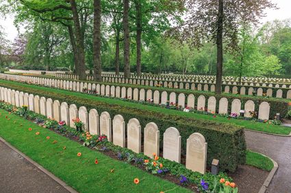
-
-
98
-
29
-
20
-
60
-
55
-
46
-
74
-
61
-
55
-
60
-
58
-
20
-
29
-
98
-
Grebbeberg military field of honour
Grebbeberg military field of honour
Grebbeweg 123
3911 AV Rhenen
-
Endpoint:
Car park at the Grebbeberg Military Cemetery
Grebbeweg 123
3911 AV Rhenen
Navigate to destination

Description
Starting point:
Car park at the Grebbeberg Military CemeteryGrebbeweg 123
3911 AV Rhenen
Navigate to starting point
The route starts from the car park at the Grebbeberg Military Cemetery (Grebbeweg 123). This route follows the signposts of the walking route network. Follow the red signs of the Utrechts Landschap.
Endpoint:
Car park at the Grebbeberg Military CemeteryGrebbeweg 123
3911 AV Rhenen
Navigate to destination
- 98
- 29
- 20
- 60
- 55
- 46
- 74
- 61
- 55
- 60
- 58
- 20
- 29
- 98